ACTIVE TRANSPORTATION RESOURCE CENTER
  • Home
  • Initiatives
    • Safe System Approach >
      • Vision Zero
    • Complete Streets
    • Safe Routes
  • Encouragement
    • Walking
    • Biking
    • Trails
    • TDM
  • Evaluation + Planning
    • Steps that local governments can take
    • Maps >
      • Active Transportation Network
      • Sidewalks, Steps, Crosswalks, and Connecting Trails
  • Education
  • Engineering - Design Guidance
  • Find Funding
  • Plan Library

Regional Active Transportation Network

Picture
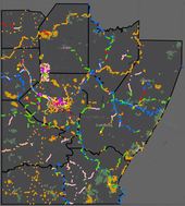
Regional active transportation network map
SPC staff developed and maintains a Regional Active Transportation Network Map. Mapped features include existing and planned land and water trails, on-road bicycle facilities and amenities like bike repair stations, bike parking and trail access/parking locations.

Other Mapping Resources
  • BikePGH
  • GoTo TRAILS

Picture

Home

About

Contact US

​Southwestern Pennsylvania Commission
Two Chatham Center, Suite 500
112 Washington Place | Pittsburgh, PA 15219
Directions | Parking | Employment | Title VI
P: (412) 391-5590 | F: (412) 391-9160
Copyright © 2018
  • Home
  • Initiatives
    • Safe System Approach >
      • Vision Zero
    • Complete Streets
    • Safe Routes
  • Encouragement
    • Walking
    • Biking
    • Trails
    • TDM
  • Evaluation + Planning
    • Steps that local governments can take
    • Maps >
      • Active Transportation Network
      • Sidewalks, Steps, Crosswalks, and Connecting Trails
  • Education
  • Engineering - Design Guidance
  • Find Funding
  • Plan Library